Ashigaratoge(Ashigara Pass) and Ashigarado (Ashigara Road) (Yagurazawa Thoroughfare)
– Natural road going North to South, Historic Road connecting east to west –
-
Historic Road connecting east to west
Ashigaratoge (Ashigara Pass) was called the hill of Ashigara
Ashigaratoge (Ashigara pass) was once called “Ashigara no saka (The hill of Ashigara)” and “Ashigara no misaka (Splendid hill of Ashigara)”. The road that passed through Ashigarado (Ashigara road) was an important government road that connected Miyako (the capital), (Saigoku (western countries) ), to the Togoku (eastern countries). In the Manyoshu, there are close to 20 songs composed about Ashigara and Ashigari, and the Ashigara Manyo Park is dotted with monuments with these poems.

Ashigara acknowledged in the Manyoshu (Ashigahara as a theme in the Manyoshu)<br />
Around the Nara Period, the Kanto and Tohoku regions were called “Togoku (eastern countries)”. In the Manyoshu in songs acknowledging Ashigara, officials who were dispatched from the capital to Togoku and people who travelled to Kyushu from Togoku to assume the role of Sakimori (guards), would pray to the god of the pass for a safe journey and many songs describing their feelings for the families they left behind in their hometowns and the hardships of going to distant foreign lands can be seen.
Title
According to the Kojiki (records of ancient matters), when Yamato Takeru no Mikoto was returning after settling in the eastern part of the Kanto Region, Ashigara Myojin transformed into a white deer and appeared while he was having lunch near Ashigara Pass. He immediately threw his leftover nobiru (long-stamen chive) at the deer hitting its eye after which the white deer died. It is said that this is from when Yamato Takeru no Mikoto made the powerful Ashigara family his subordinate.
Yamato Takeru no Mikoto stood at Ashigaratoge (Ashigara Pass) and looking in the direction of Hashirimizu (currently Yokosuka City), thought of his late wife, Ototachibnahime no Mikoto and said, “Azumahaya (Oh, my wife)” and because of this, the east became to be called “Azuma” from Ashigaratoge. It can be imagined that this location is near the current Ashigaramyojin.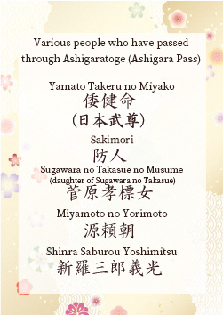
A natural road that connects north to south
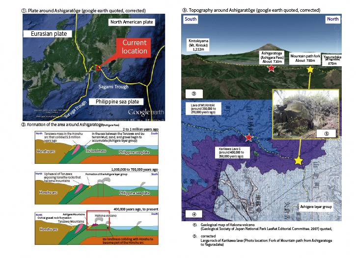
Ashigaratoge (Ashigara Pass), which has been used from long ago as a “historical road connecting east and west,” is geologically positioned near the boundary between the Philippine Sea plate and the North American plate, and is an important geosite that you can experience a “natural road connecting north and south”. (1)
The Location where North and South Connect
Ashigaratoge (Ashigara Pass) is located on the border of Minamiashigara-shi, Kanagawa Prefecture and Oyamamachi, Shizuoka Prefecture and is located at the lowest point of the ridge that connects Mt. Kintoki of the Hakono somma to the Ashigara Mountains where Mt. Yaguradake. (③)
Currently, Ashigaratoge is about 730m above sea level, however, this area was a shallow sea wedged between the Izu landmass that had been on the Philippine Sea Plate from the South Seas and Honshu until about 1 million years ago. Later, the Izu landmass collided with Honshu, the layers of sand and mud (Ashigara layer group) that were deposited on the seabed was pushed up to the surface. The Hakone volcano started its activity around 400,000 years ago, and a part of the Ashigara Mountains is covered with its ejecta, however, upheaval is still continuing. (②)
Traces Conveying the Intensity of the Collision
Manyo Park is the entrance to climbing Mt. Yaguradake. The area around Ashigaratoge (Ashigara Pass), where Manyo Park is located, is covered with lava from Mt. Kintoki (around 350,000 to 270,000 years ago). However, at the fork of the mountain trail to Mt. Yaguradake, large rocks of Karikawa lava (around 400,000 to 350,000 years ago) from an eruption of an older era, are exposed even though they are at a higher altitude than the pass. (④⑤)
The oldest lava of the Hakone volcano can be seen at an altitude of 780m, is thought to be from this area being pushed by the North American Plate and upheaved at a very high speed, even after the collision of the Izu landmass.